6 Days Shira Route - Mount Kilimanjaro Trekking
Description
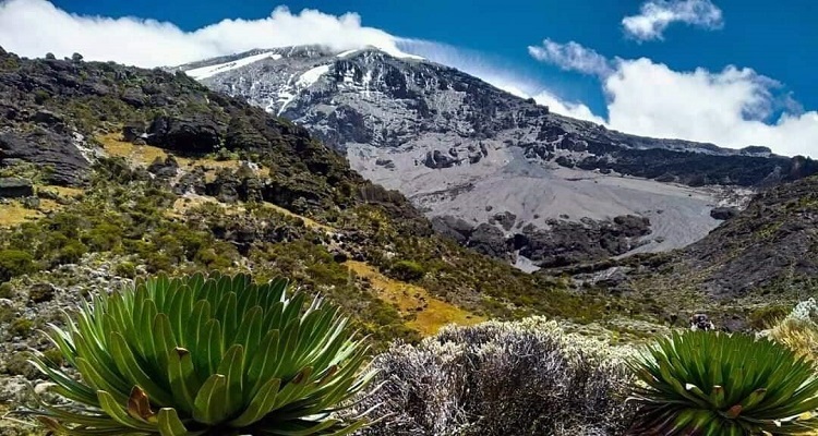
Shira Route Shira route is a little used trail that begins near Shira Ridge. It is nearly identical to the Lemosho route. In fact, Shira was the original route and Lemosho is the improved variation. Although Shira is a varied and beautiful route, it is less favorable than its successor due to the relatively high altitude of Shira’s starting point, which is accessed quickly by vehicle. It is possible that climbers will experience some altitude related symptoms on the first day while camping at 11,800 feet.
The route approaches Mount Kilimanjaro from the west, beginning with a long drive from Moshi to Shira Ridge. The vehicle bypasses the rain forest zone and the hiking trail begins on Shira Ridge. The Shira route crosses the entire Shira Plateau from west to east in a pleasant, relatively flat hike. Then the route traverses underneath Kilimanjaro’s Southern Ice Field on a path known as the Southern Circuit before summiting from Barafu. Descent is made via the Mweka route.
ITINERARY
-
- Arrival
- DAY 1: HOTEL TO LONDOROSSI GATE TO SHIRA 1 CAMP
Elevation: 11,800 ft to 11,800 ft
Distance: 4 km
Hiking Time: 1-2 hours
Habitat: Heath
Meal Plan: Breakfast, Lunch and Dinner.t - DAY 2: SHIRA 1 CAMP TO SHIRA 2 CAMP
Elevation: 11,800 ft to 12,500 ft
Distance: 6 km
Hiking Time: 2 hours
Habitat: Heath - DAY 3: SHIRA 2 CAMP TO LAVA TOWER THEN BARRANCO CAMP
Elevation: 12,500 ft to 15,190 ft
Distance: 7 km
Hiking Time: 4-5 hours
Habitat: Alpine Desert
Lava Tower to Barranco Camp
Elevation: 15,190 ft to 13,044 ft
Distance: 3 km
Hiking Time: 2-3 hours
Habitat: Alpine Desert
Meal Plan: Breakfast, Lunch and Dinner. - DAY 4: BARRANCO CAMP TO KARANGA CAMP THEN BARAFU CAMP
Elevation: 13,044 ft to 15,331 ft
Distance: 9 km
Hiking Time: 4-9 hours
Habitat: Alpine Desert
Meal Plan: Breakfast, Lunch and Dinner.
Accommodation: Barafu Camp - DAY 5: BARAFU CAMP TO UHURU PEAK
Elevation: 15,331 ft to 19,341 ft
Distance: 5 km
Hiking Time: 7-8 hours
Habitat: Arctic
Uhuru Peak to Mweka Camp
Elevation: 19,341 ft to 10,065 ft
Distance: 12 km
Hiking Time: 4-6 hours
Habitat: Rain Forest
Meal Plan: Breakfast, Lunch and Dinner. - DAY 6: MWEKA CAMP TO MWEKA GATE
Upon arrival at Kilimanjaro International Airport, you will be met and transferred for overnight accommodation at Hotel B&B. Your head guide will meet you for your briefing, gear check and arrange for you equipments .
We depart Moshi for Londorossi Gate, which takes about 4 hours; we will complete entry formalities while guides and porters prepare equipment. After registration, you continue driving into the National Park via the 4x4 access road through the forest till the Morrum Barrier, where you begin your trek. You may encounter some wild animals on your drive today in the forest reserve. Your hike today is relatively gentle and at a slow pace through the heather and moorland zone towards the Shira Plateau until your first campsite.
Today is a fairly easy day to help with acclimatization. We begin by exploring the grassy moorland and volcanic rock formations on the plateau. Then we take a scenic path to the Shira Cathedral, a huge buttress of rock surrounded by steep spires and pinnacles, before settling at Shira 2 Camp.
We continue to the east up a ridge and then head southeast towards the Lava Tower – a 300 ft tall volcanic rock formation. We descend down to Barranco Camp through the strange but beautiful Senecio Forest to an altitude of 13,000 ft. Although you begin and end the day at the same elevation, the time spent at higher altitude is very beneficial for acclimatization.
We begin the day by descending into a ravine to the base of the Great Barranco Wall. Then we climb the non-technical but steep, nearly 900 ft cliff. From the top of the Barranco Wall we cross a series of hills and valleys until we descend sharply into Karanga Valley. One more steep climb up leads us to Karanga Camp for lunch.We leave Karanga and hit the junction which connects with the Mweka Trail. We continue up to the rocky section to Barafu Hut. At this point, you have completed the Southern Circuit, which offers views of the summit from many different angles. Here we make camp, rest and enjoy an early dinner to prepare for the summit day. The two peaks of Mawenzi and Kibo are viewable from this position.
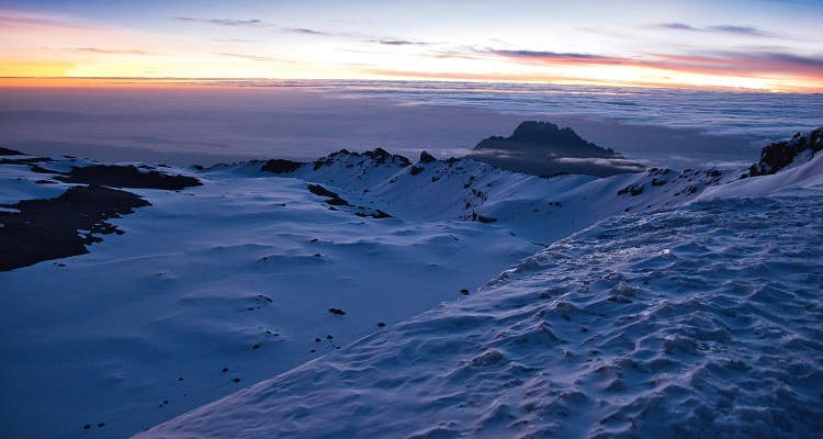
Very early in the morning (around midnight), we begin our push to the summit. This is the most mentally and physically challenging portion of the trek. The wind and cold at this elevation and time of day can be extreme. We ascend in the darkness for several hours while taking frequent, but short, breaks. Near Stella Point (18,900 ft), you will be rewarded with the most magnificent sunrise you are ever likely to see coming over Mawenzi Peak. Finally, we arrive at Uhuru Peak- the highest point on Mount Kilimanjaro and the continent of Africa.
From the summit, we now make our descent continuing straight down to the Mweka Hut camp site, stopping at Barafu for lunch. The trail is very rocky and can be quite hard on the knees; trekking poles are helpful. Mweka Camp is situated in the upper forest and mist or rain can be expected in the late afternoon. Later in the evening, we enjoy our last dinner on the mountain and a well-earned sleep.On our last day, we continue the descent to Mweka Gate and collect the summit certificates. At lower elevations, it can be wet and muddy. From the gate, we continue another hour to Mweka Village. A vehicle will meet us at Mweka Village to drive us back to the hotel in Moshi.
Incudes & Excludes, Map & Trekking Equipments
-
Price includes
>>Private transport to & from Kilimanjaro International Airport to your accommodations in Moshi.
>>2 nights of accommodation in Moshi.
>>Transportation to & from the Kilimanjaro gate
>>Park entry fees,
>>Camping fees.
>>Team Kilimanjaro Rescue fees.
>>18% VAT on tour fees & services
>>4 Season mountain tents
>>Double layered Sleeping Mats
>>Friendly and professional mountain guides, cook and porters.
>>3 hot meals daily while on the mountain.
>>Enough treated & filtered drinking water throughout the trek.
>>Hot water for washing.
>>Fair wages for the mountain crew as approved by the Kilimanjaro National Park Authority (KINAPA), Kilimanjaro Association of Tour Operators (KIATO)
>>Government taxes
>>Portable oxygen tanks & ox meter
>>Emergency first-aid kit.
Price Exclude
>>Lunches, dinners and drinks at your hotel before and after climb.
>>Travel insurance
>>Flights.
>>Laundry (Available at hotel).
>>Personal items and toiletries.
>>Tips for guides, porters and cook .
Technical Clothing:
1 - Waterproof Jacket, breathable with hood - $151 - Insulated Jacket, synthetic or down - $15
1 - Soft Jacket, fleece or soft-shell - $10
2 - Long Sleeve Shirt, light-weight, moisture-wicking fabric - $10
1 - Short Sleeve Shirt, light-weight, moisture-wicking fabric - $10
1 - Waterproof Pants, breathable (side zipper recommended) - $ 5
2 - Hiking Pants - $10
1 - Fleece Pants - $5
1 - Shorts (optional) - $5
1 - Long Underwear, moisture-wicking fabric - $5
3 - Underwear, moisture-wicking fabric recommended - $5
2 - Sport Bra (women)
Equipment
1 - Sleeping Bag, warm, four seasons - $251 - Camp Pillow, inflatable (optional)
1 - Trekking Poles, collapsible (highly recommended) - $10
1 - Head Lamp, with extra batteries - $20
1 - Duffel Bag, 50-90L capacity, for porters to carry your equipment - $15
1 - Daypack, 30-35L capacity, for you to carry your personal gear - $15
Paperwork
Passport – Valid more than 6 months.Visa (applied online but also available at JRO)
Immunization Papers
Insurance Document (That covers 6000m recommended) *
Accessories
1 - Sunglasses or Goggles1 - Backpack Cover, waterproof (optional)
1 - Water Bottle (Nalgene, 32 oz.)
1 - Water Bladder (Camelbak type, 3 liters)
1 - Towel, lightweight, quick-dry (optional)
1 - Pee Bottle, to avoid leaving room/tent at night (recommended)
Head Wear
1 - Brimmed Hat, for sun protection - $51 - Knit Hat, for warmth - $ 5
1 - Balaclava or Buff, for face coverage (optional) - $5
Hand Wear
1 - Gloves, warm (waterproof recommended) - $51 - Gloves, thin - $ 5
Footwear
1 - Hiking Boots, warm, waterproof, broken-in - $201 - Gym Shoes, to wear at camp (optional)
3 - Socks, wool or synthetic - $5
1 - Gaiters, waterproof (optional) - $5
Other Important things:
ToiletriesPrescriptions
Sunscreen
Lip Balm
Insect Repellent, containing DEET
First Aid Kit
Hand Sanitizer
Toilet Paper
Wet Wipes (recommended)
Snacks, light-weight, high calorie, high energy (optional)
Electrolytes, powder or tablets (optional)
Camera, with extra batteries (optional)
Other Trekking Information
So, you've decided to take on the challenge of tackling Africa's highest peak? Next, you need to think about the best time to climb Kilimanjaro, in terms of weather, trekking conditions and popularity. Although it's technically possible to trek Tanzania's Mount Kilimanjaro year round, there are certain months which are characterised by colder weather, more rain and potentially lots of snow on the summit. We generally advise that the best time to climb Kilimanjaro is during the warmest and driest times of year, from December to mid-March and mid-June to the end of October.
What is altitude sickness?
Also called Acute Mountain Sickness (AMS), it is an illness that can affect travellers at high altitudes, usually above 2400m (8000 feet) such as on Mount Kilimanjaro. Altitude sickness is the name given to the physiological and symptomatic reactions of the body to the low oxygen pressure (‘thinner’ air) that occurs at high altitude. When oxygen pressure falls, the body reacts by increasing breathing and heart rate and starts to produce more red blood cells. More red blood cells mean more vehicles to carry oxygen in the blood. The body also increases production of an enzyme that causes the release of oxygen from haemoglobin to the body tissues. Causes of altitude sicknessAMS is caused by reduced air pressure and lower oxygen levels at high altitudes. The faster you climb, the more likely you will get AMS. It is not only the height that matters so much, it is the rate of ascent.
You are at higher risk for AMS if you live near sea level and have had the illness before. Others at risk are those with diseases of the heart/lungs such as chronic bronchitis and asthma, people who are anaemic and those with a history of thromboses. Older people and children are also more susceptible to AMS. Symptoms of altitude sickness
Your symptoms will depend on the rate of your climb and how hard you push yourself. Symptoms usually start 12 – 24 hours after arrival at altitude and can affect the nervous system, lungs, muscles and heart. It is important to remember that reducing the symptoms is not curing the problem. The symptoms of altitude illness are similar to those of a hangover. Initially it starts with a headache, lack of appetite, tiredness and feeling off balance. Many hikers find it difficult to sleep. Then nausea sets in and vomiting starts. Headaches are getting more intense. If you continue, conditions might deteriorate. Sometimes the lack of oxygen can cause the leaking of fluid into the brain and lungs. High Altitude Cerebral Edema (HACE) and High Altitude Pulmonary Edema (HAPE) can develop. Our guides are very experienced with AMS. They will be monitoring all symptoms and will take a safe and well-informed decision on whether to proceed or descend. Most often symptoms will be swiftly relieved with decreasing altitude.
More severe acute mountain sickness includes: Blue skin and lips (cyanosis) and grey or pale complexion
Tight chest
Cough and coughing up blood
Confusion, decreased consciousness or withdrawal from social interaction
Not being able to walk in a straight line or unable to walk.
Prevention of altitude sickness
The slower you go, the better you will acclimatise and the higher you are likely to go without experiencing many symptoms. Recognise early symptoms of AMS and if symptoms increase, descend. Your guide will help you take a decision. The only cure is either acclimatisation or descent.Walk slowly, relax and enjoy.
Drink plenty of fluids while climbing, at least 3 to 4 liters of water per day.
Avoid alcohol when ascending
Talk to your doctor before you attempt to climb Kilimanjaro and ask about the correct preparation, first-aid medication and treatment options for AMS. If you are anaemic, ask your doctor for an iron supplement.
Colds
The risk of altitude sickness will be increased if you are already suffering from respiratory tract infection such as a cold. If you have the flu, do not travel until you are fully recovered. Both colds and the flu are caused by viruses and anti-biotics will not be effective as it is used against bacterial infections.Acute upper respiratory tract infections include pharyngitis/tonsillitis and laryngitis. Complications may lead to sinusitis, ear infection and sometimes bronchitis which can all be exacerbated by high altitude.
Some research has shown that restrained exercise might not change the severity and duration of the illness, but the intensity of a Kilimanjaro hike will jeopardise your recovery. Getting plenty of sleep is advised as sleep deprivation is associated with increased receptiveness to infection.